


By Lillian Boyd and Shawn Raymundo
How will Dana Point be impacted by sea level rise?
The past month saw an increased amount of activism and engagement centered around climate change and the potential threats of sea level rise, in light of the United Nations Climate Action Summit on Sept. 23. Millions participated in the Global Climate Strikes from Sept. 20-27 to demand action on climate change. The nearest strike to Dana Point was held in Laguna Beach.
On Sept. 24, Jack Ainsworth, the California Coastal Commission’s Executive Director, issued a statement regarding the Intergovernmental Panel on Climate Change (IPCC) Special Report on the Ocean and Cryosphere in a Changing Climate.
“This report shines a light on what we have all been observing around the world,” Ainsworth said. “We are now witnessing unprecedented heat waves, accelerated ice sheet melt, massive wildfires, and devastation from amped up storm events that are all happening with frightening frequency.”
For the IPCC Oceans Report, more than 100 scientists from more than 30 countries assessed the latest scientific knowledge about the physical science basis and impacts of climate change on ocean, coastal, polar and mountain ecosystems, and the human communities that depend on them. The report also addressed sea level rise and implications for low lying islands, coasts and communities.
In the Sept. 23 California Coastal Commission (CCC) meeting, Mary Matella, a CCC environmental scientist, gave a presentation on how sea level rise impacts Orange County and what coastal cities are doing about it.
Local and regional adaptation planning efforts will be critical for ensuring that coastal communities can be resilient to sea level rising in the coming years, Matella said. The CCC’s Local Coastal Program (LCP) is a planning tool used by local governments to guide development in partnership with the CCC. LCP’s contain the ground rules for future development and protection of coastal resources in the 76 coastal cities and counties.
“Now that we’re in the sixth year of the LCP grant program, we have awarded almost $6 million, for 50 projects in 37 jurisdiction, 32 vulnerability assessments,” Matella said.
The grant program offers funding for cities to assess vulnerable coastal areas that could be threatened by sea level rise and provides the opportunity for each city to update its LCP. The study is meant to identify areas of the coastal region that are vulnerable to hazards while considering policies and programs to mitigate such threats.
A resolution to allow Dana Point city staff to apply for a second grant from the CCC appeared on the Oct. 1 Dana Point City Council meeting agenda’s consent calendar.
In 2016, the CCC awarded Dana Point a grant in the amount of $135,000 to complete a SLR Vulnerability Assessment to evaluate and model sea level rise scenarios in conjunction with other coastal flooding factors.
The draft report is near completion and will go through public outreach and review before being presented to the council prior to the end of the year.
City council approved the consent calendar, allowing staff to request a grant in the amount of $120,000 to continue the efforts of the previous grant to identify appropriate policies for inclusion in the city’s Coastal Land Use Plan.
“(The CCC grant program) is split in different phases. The City of Dana Point is nearing completion of the first phase, which is the vulnerability assessment,” said Matt Schneider, the city’s director for community development. “We are nearing completion and anticipate that the report will be released for public review this month, and go before city council in November.”
Schneider says the assessment has taken this long due to the time it takes to input localized data in the CoSMos 3.0 model.
The second phase, which Schneider clarified pertains to what appeared on the council agenda, will allow the jurisdiction to look at its LCP to see if changes need to be made per the vulnerability assessment.
“Most of the sandy beach in Dana Point is not controlled by the city. It’s controlled by the state and county,” Schneider said. “So a lot of this will involve coordinating with other agencies to address vulnerability.”
The second phase to this will be about policy and regional coordination, generally speaking, Schneider said. This could include coordination with Capistrano Bay District, a Special Government District that represents the residential properties along Beach Road in Capistrano Beach.
Capistrano Bay District has not initiated a sea level rise assessment, but Beach Road was included in Dana Point’s SLRVA. Details of which areas in Dana Point are considered vulnerable to sea level rise will be released by the city this month.
The 189 homes on Beach Road, and a few vacant lots, sit on the beach, adjacent to county-owned Capistrano Beach, which has faced severe damage due to inclement weather. While Beach Road properties are seeing the impacts of coastal erosion, Capistrano Bay District Manager Donal Russell says it isn’t necessarily the result of sea level rise.
“What we see is long-term loss of beach from wave action in the summertime. It’s a different angle that cuts into the sand on the beach, causing shoreline erosion,” Russell said. “I suppose, decades from now, we could see sea level rise impacts, but right now we’re seeing soft swells have more energy as a result of climate change.”
Russell says homeowners are implementing sand bags to combat the beach erosion.
“Fingers crossed that this helps,” Russell said.
Some areas of the 1 ½-mile mile stretch of properties aren’t as impacted, Russell said. Some pockets avoid much of the impact. The sand loss has also exposed cobble in the ground, which absorbs wave run-up. Russell says this has been a great natural barrier.
“The big question is whether climate change is natural or man-made,” Russell said. “But we’re seeing rising sea surface temperatures and beach erosion.”
In San Clemente, Cecilia Gallardo-Day, the city’s community development director, described the SLRVA, or study, as “factual information about what we can expect in the future and what infrastructures or coastal resources could potentially be vulnerable.”
The study, she also noted, will be the basis of the city’s Coastal Resiliency Plan (CRP) that’s currently in the works and should be released for public review in 2020. The Resiliency Plan, she said, will detail the city’s options on how to mitigate and adapt to sea level rise.
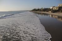
According to the daft of the Vulnerability Assessment, sea level rise poses the biggest threat to the city’s public resources and infrastructure.
“The primary vulnerabilities in the City include increased shoreline and beach erosion, wave flooding, and tidal inundation,” the report states. “Unlike in other low-lying cities where SLR can threaten private developments due to flooding or erosion, SLR in San Clemente first threatens the public resources of the public beach.”
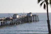
It also notes that damage to the pier, Marine Safety Building, railroad and other infrastructure from coastal hazards and storms aren’t “new phenomena.”
“The effects of storms will increase in magnitude with higher water levels,” the draft report’s findings on public beaches states. “Beach nourishment will help to maintain beach width in the short term, but higher water levels will make sandy beaches very difficult to retain impacting recreational opportunities available on the dry beach areas.”
The long-term consequences to the city’s beaches, the draft SLRVA points out, could be “near total loss” and “loss of recreation including surfing.”
The roughly 2-mile-long California Coastal Trail from North Beach to San Clemente State Beach could potentially need “permanent adaptation” or be relocated altogether, as there is likely to be a loss of continuity along the beachside portions.
“Maintaining continuity of the coastal trail will become increasingly difficult in the long-term as trails on the beach side (Central Reach) will be exposed to direct wave action seasonally or year-round,” the draft of the SLRVA states.
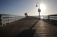
As for the pier, the city found that the long-term consequences of sea level rise include “damage from storm waves, erosion of beach behind pier, potential for temporary flooding.”
The draft of the Vulnerability Assessment has made its way through the city’s Planning Commission and Coastal Advisory Committee for review and comments. That draft report, which also underwent a public-comment period in August and September, is set to go before the city council for review in early November.
In an interview with Dana Point Times, Kelsey Ducklow, a climate change analyst for CCC, says that sea level rise causes erosion in bluff areas, flooding, and worse impacts from storms and high tide.
“Armoring is a technique of building sea walls in shoreline to protect development and infrastructure from erosion,” Ducklow said. “This stops the beach from eroding inland, but it blocks the beach from migrating, creating a coastal squeeze. Beaches are subsequently lost.”
Ducklow has been on CCC staff for about six years and was a key staff member who worked on sea level guidance, which was adopted in August 2015 and updated in November 2018.
The CCC and partnering cities use the program CoSMoS 3.0 to assess where a community is most at risk. The software looks at built assets such as houses, roadways and highways, as well as natural assets, including beaches. The modeling tool was developed by the US Geological Survey.
Ducklow says the models implement scenarios of a sea level rise between 3 and 6 feet.
“Six feet is on the conservative end. The CCC requires that cities plan out to at least the year 2100, implementing up to six feet of sea level rise,” Ducklow said.
As of now, 37 out of 76 jurisdictions have done the assessment.
“In regards to the jurisdictions that haven’t yet initiated an assessment, I don’t think that it’s because the issue (of sea level rise) is being ignored,” Ducklow said. “I think it’s that some of these jurisdictions lack the resources and capacity to start planning for these kinds of issues.”
In 2017, the city of San Clemente received a $135,000 Local Community Program (LCP) Planning Grant from the California Coastal Commission to prepare the Vulnerability Assessment. The city was also awarded a $75,000 LCP grant in 2018 to put together the Coastal Resiliency Plan.
Gallardo-Day explains that the SLRVA and CRP are part of the city’s larger goal to get a CCC-certified LCP, which contains two primary components: a Land Use Plan (LUP) and a Local Implementation Plan (IP). These components provide measures to implement the plan, such as zoning ordinances.
“The adoption of a new LCP will give the City more control over approving projects within the City’s Coastal Zone and will streamline the Coastal Development Permit review process for applicants,” according to the city.
The CCC certified an updated version of the city’s LUP in August 2018. The city is currently drafting the IP, which is expected to be released for public review and comment next year.
In Ainsworth’s statement on sea level rise, he emphasized the significant risks to coastal communities, critical infrastructure, wetlands, sandy beaches and coastal economy.
“We owe it to our children and future generations to plan for resilient communities while we can. History will judge us harshly if we do nothing or take half-hearted steps,” Ainsworth said. “(This) is a call to action for proactive science-based planning to address this looming disaster with a sense of urgency.”