


Without any discussion on the matter, the San Clemente City Council voted by a 4-1 margin on Tuesday, April 16, to advance District Map No. 120.
Mayor Victor Cabral voted ‘no’ on the motion, which came during a public hearing item.
Tuesday’s vote marked the third different district map to be introduced since the city began its transition to by-district elections in response to a litigation threat under the California Voting Rights Act.
The council officially approved the transition on Nov. 7, 2023, the last meeting possible before venturing beyond one of the CVRA’s safe harbor provisions. At that same meeting, the council introduced Map 109, which divided the Forster Ranch and Marblehead Inland Specific Plans into District 1, Talega and Rancho San Clemente into District 2, Marblehead Coastal and the Shorecliffs area into District 3, and southwest San Clemente into District 4.
With debate over whether Forster Ranch or RSC belonged in the Talega district, current Mayor Victor Cabral joined current Mayor Pro Tem Mark Enmeier and Councilmember Chris Duncan in voting to introduce Map 111 at the Dec. 5, 2023 meeting. On Jan. 16, Cabral flipped again as he and Councilmembers Steve Knoblock and Rick Loeffler voted against adopting Map 111 on second reading.
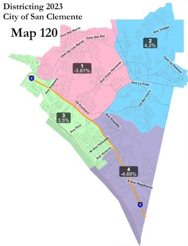
Map 120 varies from Map 109 in that 120 brings the Pier Bowl community of interest all into District 3. District 1’s population under Map 120 is 15,611 (a negative-3.01% deviation from the CVRA’s ideal number), District 2 contains 16,772 (positive 4.2%), District 3 has 16,660 (positive 3.5%), and District 4 has 15,341 (negative 4.69%).
The map would come back for adoption on second reading at the council’s May 7 meeting, and if adopted, would be effective as of June 6 (30 days from May 7). The deadline to submit a finalized district map to the Orange County Registrar of Voters to ensure it’s in effect for the Nov. 5 general election is July 3, according to the staff report.